Place names are part of the culture of a people: geographical features, human settlements, rivers, springs, mountains, even farmland, have their own name. In this entry we will talk about the toponyms of CÍES. More specifically of the island of San Martiño. The R.A.E. defines “toponym” as “.
1. m. Ling. Proper noun of place. (From the Greek “topos” place).
The inhabitants of towns and villages are the main repositories of this immaterial culture. The proper names of places speak of their history, their location, their physical resemblance to an animal or a character…. In short, place names are part of our wealth and it is important to preserve and know them. It often happens, with the depopulation, the abandonment of lands and villages, that these place names are lost.
Place names of CÍES
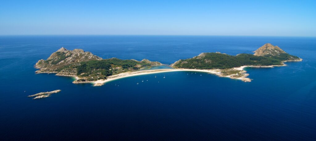
Iván Sestay, philologist from the University of Vigo, writer and translator, has been one of the people most concerned about the preservation of the toponymy of the Cíes Islands. In 2020 he had collected and catalogued more than 500 toponyms of the Cíes Islands in serious risk of disappearance. We will start by knowing some of the illa de San Martiño or illa do Sur. First of all, the two main islands of the archipelago, illa de Monteagudo and illa de Montefaro, are separated from the third, which concerns us, by a strait. This strait is called Freu da Porta, or simply A Porta, and it is a strait of about 500 meters. Logically, a passage between two “walls” can only be “a door.”
The Furnas of CÍES
The furnas, cafurnas or caves, are cavities carved into the rock by the force of the push of the sea. Although those of the island of Ons are more famous thanks to the famous “Buraco do Inferno” and to the observation of them from the cove of Caniveliñas, Cíes has its own. On the island that concerns us, San Martiño, we can find, to the north, the furna da Fornaca da Galera. It takes its name from a cape in the north of the island called Punta da Galera , which also lends its name to the cón da Galera. The “cón” is a large rock or boulder that emerges from the sea near the coast. Another furna of Cíes, in San Martiño, is the furna of Fornaca da Xestosa, which is located between the points of Xestosa and Xesteira. It is located on the eastern side of the island, facing the Vigo estuary. Further south, on the same eastern side of the island we find the furna da Suaponte, the furna da Serpe, and the furna da Fornaca ro Raio. On the Atlantic side of the island we find two more furnas, the furna da Balcoeira and the furna dos Gavotos. The gavotos are the young of the gulls, gaivotas (also gavotas) in Galician.

Points and inlets
In the south of the island of San Martiño we find the first two coves, the enseada do Limpiño and the enseada dos Lumbrigantes. The first one seems to be a good place to shelter in case of storm. As for the second … perhaps it is a good place to catch a lobster, with which to prepare a delicious rice stew. The points and points are minor protruding headlands on the coast. The northernmost point of the island of San Martiño is the Pau da Bandeira point. To the south are the Punta da Penela do Limpiño, next to the inlet of the same name, and the Punta do Cabaliño. On the Atlantic coast of San Martiño are the Falcoeiro point and the Gavotos point, of the same name as the furna. There is also the Pé de Cabra point, which, as its name suggests, resembles the hoof of a goat. The bovine is also used to name the restinga de Pé de Cabra and the petóns de Pé de Cabra. A restinga is a surface of sand or rocks at shallow depths, while the petóns, like the cóns, are isolated rocks jutting out of the sea.
Cantils, penelas, leixóns, laxes, baixos, pedras, and of course areas, are other geographical features with their particular toponyms. The beach of the island of San Martiño is called area de San Martiño, 520m. long and 35m. wide. It can only be accessed by private boat.
On land
Mountains, crosses and houses also have their own names on the island of San Martiño. To the north are the cross do Ave de Mar and the houses dos Prácticos and do Norte. Also the mountains of O Pitosago ( 121m.) and O Carboeiro (122m.) and the cross of San Martiño. In the southern part of the island are the muíños: the muíño do Limpiño, which uses the water of a small river called A Presa with mouth in the cove of the same name to which we referred earlier, and the muíño da Ferraría. The latter uses the waters of the river da Granxa. From the name we can venture the existence in its day, of a blacksmith’s shop that supplied tools to the inhabitants of the island. The highest point of the island is O Monte Pereiro, 172 m. Not far from there, towards the center of the island is the hermitage of San Martiño (a lapeira do santo). The hermitages are small hermitages excavated or that take advantage of a hole in the rock. This one is dedicated to the same saint who gives his name to the island, as it could not be otherwise.
A whole universe of names of its own on a small island
Not everything is Rhodes Beach in the Cíes Islands. The Guardian’s recognition as the best beach in the world undoubtedly served to launch the archipelago to tourist stardom. It also served to advance the preservation of the National Park and its treasures. We cannot leave the intangible treasures of the Cíes unprotected. The toponymy is part of those treasures that “enriches” us culturally to preserve. Without A Zoqueira, As Laxes Saídas, O Cabo de Bicos, Os baixos da Pedra Morta, O leixón do Xibarte, A pedra do Catalán, A area de Sardeiros, Os cons de Concela, O Forcado de Fóra, O cantil de Pitosago, A Perigosa, or the sea of Sardeiros, the Cíes Islands would have one point less in their honors in wonders.
Do you want to know more about the CIS ISLANDS? In this link we tell you 5 curiosities about Cíes, enjoy it!


